In Ontario, there are approximately 250,000 lakes. A majority percentage of these are located off the beaten path, in Northern Ontario. An area in particular that will always have my heart is the Magnetawan River, it’s tributaries and the remainder of the watershed. I frequent this area and have thoroughly enjoyed my time, but for this case study we will be talking about a lake that you have probably never heard of. I am doing this to show you that this can be done for almost any water body.
Picking your lake
The lake that will be the subject of this case study will be Squaw Lake, part of the upper reaches of the Pickerel River, near the French River in Northern Ontario. I first ventured to this area while working as a summer student at the nearby Grundy Lake Provincial Park. It is only accessed by a logging road and has all the attributes of a lake I want to fish and backcountry camp on.
General Google Search
Once I have picked a lake, I begin to dive into Google for any information possible. I searched “Squaw Lake Fishing”, “Squaw Lake Ontario” and various other terms. This provided the base for my knowledge, and some lakes you will find message boards talking about the lake you picked. For Squaw Lake in particular, I found only one message board speaking of my lake and it only mentioned the the area briefly in regards to passing through the area canoeing.
Many areas have fish assessments done by various stakeholder groups that are available to the public. For Squaw Lake, it was mentioned in the Pickerel River Fish Habitat Assessment (found here: https://www.stateofthebay.ca/wp-content/uploads/2018/12/Pickerel-River-full-report.pdf). For long documents, use the find tool on your browser, I searched “squaw” and it was included 62 times. This report included tons of information, but some interesting things applicable to what I was doing was the water temperature and dissolved oxygen readings at the downstream Squaw Rapids. It also included up to date photos of the rapids and aerial drone imagery that helped provide context to what you will be dealing with when you actually go to your lake. After further research on the document it also said that walleye and white sucker eggs were found within eggs matting, which is a good start for identifying target species.
MNRF’s Fish ON-Line
The entire point trip is to chase some fish, possibly some that are forgotten about and face next to no angling pressure. There is a perfect tool for this, aptly named Fish ON-Line, which is a wealth of information on its own.
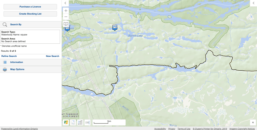
As you can see, Squaw Lake isn’t officially named on the tool, and therefore there is no records of the types of fish in the waterbody. This can be common, as many lakes are named on a more local scale. This doesn’t mean that the tool isn’t useful, as you can look at nearby lakes to get an estimation of what lives in the lake. I will use Byrne Lake for this as it is very close-by and is connected to Squaw Lake at high-water times through its drainage basin. This is what is listed on Byrne Lake:
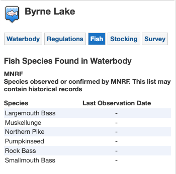
Due to their proximity, I feel comfortable assuming these species also inhabit Squaw Lake, and they echo what is found downstream as well. One final note on this is that there are many other types of fish that may live in the lake you are searching, but in the past they might not have been thought of as a ‘Sportfish’ so they weren’t recorded. Channel Catfish is an example of a species that wasn’t historically recorded or the sampling techniques discriminate against bottom-dwelling species.
Bathymetry
A tool that makes finding fish much easier is the bathymetry, essentially it maps out the floor of the lake and gives insights on depths and areas that may hold fish. For many waterbodies, this data will be accessible and may be part of an app such as Navionics. If it is a major lake or was of economic importance in the past, the bathymetry will likely easily available. For bathymetry on a forgotten lake like Squaw Lake, it gets a little trickier.
After failed searches on all the usual avenues, I found myself on the Historic Bathymetry Maps webpage on Ontario Geohub. This is the blurb from the site:
Historical Bathymetry Maps
“Between 1948 and 1995 the Ontario Ministry of Natural Resources and Forestry (MNRF) captured bathymetry data for over 11,000 lakes across Ontario.
The historic bathymetry maps were created using simple methods to determine lake depths and were meant for resource management purposes only. Very little effort was made to identify shoals and other hazards when creating these bathymetric maps. Since the data was collected a number of both constructed and naturally occurring events may have resulted in the depth information becoming inaccurate. For this reason the historic bathymetric maps should not be used for navigational purposes. The data can be used for the purposes of fish monitoring and other ecological applications, watershed based water budgeting, hydrologic cycle modelling, climate change modelling and by the general public. In many cases, these maps still represent the only authoritative source of bathymetry data for lakes in Ontario.
These maps are being converted to digital GIS line data which can be found in the Bathymetry Line data class. The Bathymetry Index data class identifies if GIS vector lines have been created. The historic paper maps have been scanned to digital files. Any new digital files will be added to this dataset if they become available. The digital files have been grouped and packaged by regions into 13 compressed (zipped) files for download.”
I followed the instructions on the site, and downloaded the correct maps package. Using the Excel look-file I searched “Squaw Lake” and surprisingly, I got a match. It said that the corresponding map was made in 1997 and the filename was “17-5498-50934”. A quick search of the file and I laid my eyes on one of the most beautiful, and useful documents I had ever seen.

This is exactly what I was looking for, and I appreciated the fact that it was hand-drawn and even included some calculations from its making. This was a great find, but I wasn’t sure about the how different water levels could affect the measurements on the map. This is where I needed to call in a favour, someone that is a lot handier on computers than myself. I send this file to a friend, and he used various programs to make a .PNG file that I could use in Google Earth. I was able to insert the .PNG file as an overlay on the satellite imagery.

As you can see, it’s pretty amazing how well the map fits the current water levels. A print out of this screen laminated on a trip is more than enough to help put yourself in the best situation to catch fish. With the information gathered to this point, I would feel comfortable making a trip out to the lake and I think I would have a general idea on what spots to target.
The last piece of useful information I found were various lake specific fact sheets from Muskoka Water Web. There was one for Squaw Lake and includes species that occur and other information about fishery surveys of the area. Of course, I stumbled across this sheet after all my other research was done. The website where these fact sheets are located is http://www.muskokawaterweb.ca/lake-data/mnr-data/lake-fact-sheet.
After doing this research all winter while dreaming of summer fishing, I am all prepped to have a successful fishing trip. All the research in the world can’t guarantee fishing success but I believe that it can only help the cause, and I think it gives you a view of the lake dynamics as a whole. Now that you’ve seen how to analyze Squaw Lake, pick a lake of your own and begin the journey.
Hopefully I don’t see you out on Squaw Lake, but if you do happen to be out there, I’m the guy in the green canoe. Remember to wear a life jacket and do not under any circumstances forget your Sab Spinner. This is the biggest mistake you can make.
Keep Casting,
Nate

did you ever end up catching on Squaw lake?
LikeLiked by 1 person
Thanks for the comment Mike. I have caught some big ones there for sure. Some very, very good fishing up in those parts.
LikeLike